
.
As not that many people pass by Llactapata, it would be good to have any reports back on current state of ruins – pls comment below
.
UPDATE 2016: a short video of the expedition is now available to view on Youtube
.
Summary
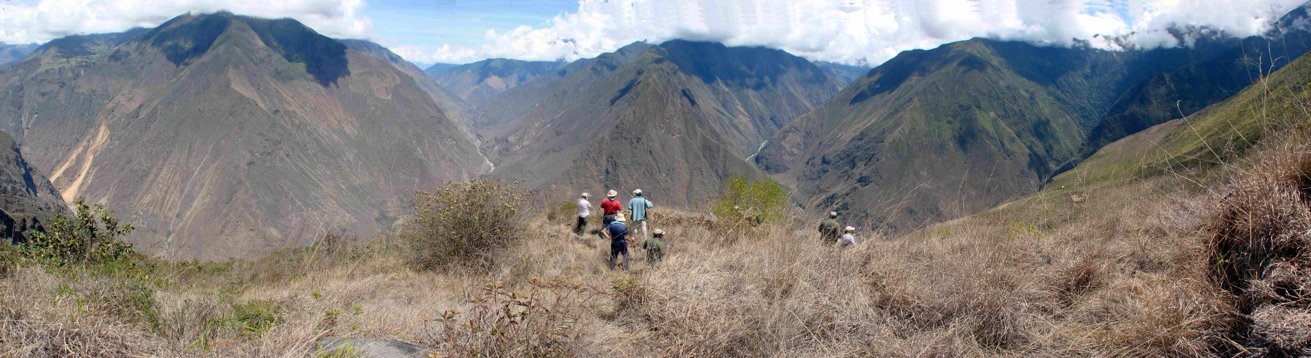
On Thurs, Nov 6th, 2003, it was announced in London that an Anglo-American team, supported by The Royal Geographical Society, had found that the site of Llactapata, located in the Peruvian cloud-forest not far from Machu Picchu, was far larger and more significant than had previously been thought.
Flying over the Andes, the team had first experimented with infra-red cameras to try to see through the thick jungle vegetation and reveal the outlines of stone buildings beneath.
They had then travelled overland with a mule-team and cut their way through to the substantial site, which lies at around 9,000 ft in the Eastern Peruvian Andes.
The expedition found that the central plaza at Llactapata has ceremonial doorways aligned to Machu Picchu, the great Inca centre which can be seen in the distance. There is also a two-storey temple, which faces the rising sun.
The team was led by the British writer and explorer Hugh Thomson and the American archaeologist Gary Ziegler.
.

.
The only previous identification of the main sector of the site had been by the American explorer Hiram Bingham in 1912, but he left such an inaccurate account of its position that no expedition has been able to give a report of it since, although they have found other smaller sectors nearby (Thomson had himself been a member of one of those other expeditions in the early 1980s, as he described in his book The White Rock).
The Thomson-Ziegler expedition both re-located this main sector and also identified and mapped as many as five sectors spread out over several square kilometres across a hillside, making the Inca settlement of Llactapata a site of some magnitude overall.
In the full report they issued on the site (later published in the Revista Andina), the team members analysed the complex set of alignments between Llactapata and Machu Picchu, which suggest that Llactapata was designed as an observatory site for its larger neighbour. See full report

.

.
In particular, a remarkable long sunken passageway was discovered that runs almost 150 feet back into the hillside, without doors or exits to either side, with a sight line to Machu Picchu at its far end directly over the various valleys in between. Further investigation by Dr Kim Malville showed that the corridor was aligned so as to be exactly in line with sunrise at the June Solstice, and with the rise of the Pleiades constellation, used in the Andes in the pre-Columbian era to mark the beginning of certain agricultural seasons.
It therefore seems the Incas may have built Llactapata as a place from which they could both admire Machu Picchu and use it to take astronomical readings.
The layout of the main buildings also corresponded in a quite remarkable way with the layout used at the Coricancha, the main Sun Temple in Cuzco. It is well known from the chronicles that the Incas used the Corcanca as a template for similar smaller scale buildings throughout the Empire. See full report for detailed discussion of this.
The well-known anthropologist and explorer Johan Reinhard, who discovered the ‘ice-mummies’, commented: ‘Thomson and Zieglers’ important discovery reinforces the need to expand the Machu Picchu Historical Sanctuary’s borders to include and protect a wider area.’ At present the Llactapata ruins lie outside the protection of any Peruvian National Park and so are vulnerable to looters.
Background
 .
.
.
The expedition was supported and approved by the Royal Geographical Society and by the Mount Everest Foundation.
The 17-strong team included an expert on archaeoastronomy, Dr Kim Malville, Professor Emeritus at Colorado University, the veteran British explorer Nicholas Asheshov, whose first expedition for National Geographic was in 1962, and the Australian explorer John Leivers, as well as Peruvian, British and American field workers. Many of the team had worked with Thomson and Ziegler on their research expedition to Cota Coca the previous year.
.
.
.
Location

.
Llactapata is approximately 50 miles north-west of Cuzco, the old Inca capital, and only two miles west of Machu Picchu, in the Aobamba valley ( it should not be confused with the well-known ruins at Llactapata/Patallacta at the start of the Inca Trail, higher up the Urubamba). One curiosity about the site is that it should be so close to Machu Picchu, which half a million visitors travel to each year, and yet have remained so unexplored.
.
Press
In Peru, the expedition’s report and analysis of the site was published in Spanish in a full, illustrated 11,000 word lead article by the Revista Andina, (#39), the leading Andeanist academic magazine, which also published peer-reviews of the findings by specialists in this field, Tom Zuidema, Vincent Lee, Jürgen Golte and Peter Kaulicke.
For a translation of the full Revista Andina article on the expedition in English
This is The full report on the expedition
In the UK, the expedition’s discoveries were reported by the Daily Telegraph, Independent and Guardian, and in the USA by the New York Times and LA Times, along with many other publications worldwide.
Hugh also wrote a personal account of the findings for the Daily Telegraph Magazine: See Hugh Thomson’s article for Telegraph Magazine
Illustrated article on expedition in the South American Explorers Journal Spring 2005
.
Update 2009: One primary aim was to encourage the Peruvian authourities to restore and maintain the ruins which, as Johan Reinhard commented above, lie outside the Machu Picchu Historical Sanctuary’s borders and on private land. As a result of the expedition, some of the central Sector I has now been cleared and restored, and grass laid in the surrounding area – although not the sunken passageway beside it, or the other sectors, which all urgently need increased conservation.
Indeed one problem that has arisen from grassing the area around Sector I is that locals are now using the area as a pampita on which to graze cattle: the cattle are inflicting a great deal of damage on the buildings, particularly the sunken passageway which when Hugh Thomson returned with a PBS / National Geographic film crew in June of 2009 was showing significant signs of wear, as cattle were allowed to roam along it.
An article in the Peruvian magazine Caretas by Nicholas Asheshov has drawn attention to this problem: see translation into English.
.
Diagram of principal sectors at Llactapata
.

.

.
Note the double-jambed doorway facing out at both sites at end of passsageways, with similar orientation.

.
Note sunken enclosed passageway similar to Sector 1, marked as 5 on diagram. This sector is very close to and just above the small pampa now used by trekkers over-nighting as a camping site.
.

Located some 100 metres from the uphill side of Sector I and only 30 metres higher in altitude, this sector is associated with Sector I.
.
As of 2009 it was very overgrown and had been visited by huaqueros, who had partially destroyed the important building 4, one of the few at the site to be made with granite. The whole sector urgently needs conservation and further study. The large ushnu sructure is a 60 feet by 40 feet raised, earth filled platform, enclosed by a five feet high retaining wall. It is connected to building 4 by a 60 feet long low wall. Stone steps lead onto the platform from the northeast side. The platform is aligned 20 degrees by 110 degrees. and overlooks Sector I below.
.
As not that many people pass by Llactapata, it would be good to have any reports back on current state of ruins – pls comment below
I visited Llactapata in 2008 (at least I think it was Llactapata, our guide called it Paltallacta) at the end of a trek that started at Cachora (to Choquequirao). Unfortunately we didn’t have a lot of time to explore …and at the time I wasn’t aware of the size of the ruins.
There are a couple of photo here, if you’re interested: http://www.pbase.com/nosferatu/pajonal_victoria_to_aguas_callientes
Cheers,
David
Submitted on 2012/07/20 at 8:31 pm
hello Hugh,
last week I went to Llaqtapata
only saw 1 sector cleaned, in the highest part, was that sector 3 or sector 1? It has one huge building and there are remains of houses or deposits near. In between is that walkway you are writing about. It is deteorating more I think. They put some ‘palos’ to avoid the walls falling down.
Tried to enter in the woods to find the houses, but all is covered and we didn’t have a machete.
The family that is living below is planning to start a kind of hostal, they built a place where you can sit under a roof.
The trail is very nice to walk!! What is the sign “Punkalloc” in the pass referring to? We didn’t see any special thing.
I have some pictures, send me an email if you want to see them,
greetings, Dineke Veerman, Dutch tourleader and teacher, have lived in Cusco 1996-2005, having done a lot of hiking
Tx so much Dineke
Sector 1 is the section that has been cleared.
Sector 3 with the ushnu and fine granite room (partially destroyed by huaqueros since our work there) is in the woods just above Sector 1 and very overgrown.
Sector 2 is just behind the campsite clearing, to the right of the path as you set up hill, and is easier to investigate.
Hugh
Hi,
I visited Llactapata in September of 2013. Some of the buildings seem to be restored and the area around them cleared. Im sure cattle still roams freely and campers camp right there. Lovely sight though. Would be great to see it truly preserved.
Hi Hugh,
I walked around Llactapata this week. Sector 1 was the only area distinguishable. The main building was cleared and well maintained. The other buildings were semi-cleared but deteriorating badly. Access to Sectors 2 and 3 was not obvious, all appeared overgrown.
There was a tremendous amount of clearing and development along the top. I believe this is the area marked sector 5 and miradores on your map. Signs in this area called it mesapampa; there are now multiple tiendas, lodges, and commercial camping areas built here. I couldn’t find any signs of Inca buildings. There’s still a trail headed towards Sector 4 but it was fenced off and I chose not to explore.
I chatted with a few of the locals living nearby, happy to share what i heard if you want to email.
Thanks for all the work you did there.
Cheers,
Craig
Thanks so much Craig for sending this – I do appreciate it and I have tried over the years to direct the authorities’ attentions to more preservation of the site – and particularly to dissuade cattle from being grazed near the ruins as they do more damage than any cloud forest could.